

Trail Tracker maps and displays journey's for safe outdoor adventures
Use Trail Tracker while enjoying outdoor activities such as trekking, hiking, boating, walking, running, cycling or any activity where your journey or adventure needs to be saved or shared.
Key features
• Record and manage journey locations
• Share using Email or Cloud Services
• Import using Email or Cloud Services
• Share files with Google Earth
• Pre-set messages allow quick option to share location
• Use the Pin feature to save 25 locations
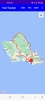
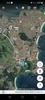
• View with normal or satellite map
• Use the Google Map Directions
• Use the Google Map Address feature
• Share locations using pre-set or customised Text messages
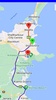
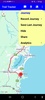
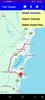
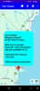
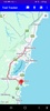
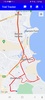
As a journey proceeds, Trail Tracker can record up to 5400 map coordinates which can be displayed as a map overlay to show the travel path, pin markers show the starting and finish locations with details on remaining record time and the estimated distance travelled.
The estimated travel distance is the sum of the calculated distance between sequential GPS locations.
Journeys can be saved to the phone or shared using Email or a Cloud Storage service, Shared journeys are compatible with Google Earth to allow journeys to be saved and managed independent of Trail Tracker.
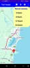
The journey recording option has 4 sample intervals
• 3 hours with a 2 second sample
• 6 hours with a 4 second sample
• 12 hours with a 8 second sample
• 24 hours with a 16 second sample
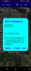
Pre-set messages can be shared using multiple platforms such as social media, email, SMS etc. These messages will contain a short status message which can also be customised and fully controlled by the app user. The shared message will also include the current GPS location as a link which can the receiving user can select to open Google Maps to show your location.
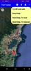
Tag and save 25 favorite locations, map pins also show location information. This feature is requires network connectivity for the location information to be displayed.
Location uses GPS satellites to provide the locations used to map journeys, however indoor locations may affect the accurate detection of GPS satellite signals.
Menu options are dynamic, showing the allowed options. As an example the option 'Show journey' will not be available if recording has not been started.
Map zoom can be set using the screen pinch or finger tap methods. Map zoom settings are saved and used when the app is restarted.
Trail Tracker requires
• Permission to access GPS & Location
• Permission to use Background locations
• Permission to use Fine Location service
Requirements (Latest version)
- Android 7.0 or higher required
Comments
There are no opinions about Trail Tracker yet. Be the first! Comment